Musquodoboit Trailway Guide: Rail Trail, River Views, and Ridge Loops
Affiliate note: This article may contain affiliate links, which means I may earn a small commission if you book or buy through them – at no extra cost to you. I only recommend things that make sense for this kind of trip.
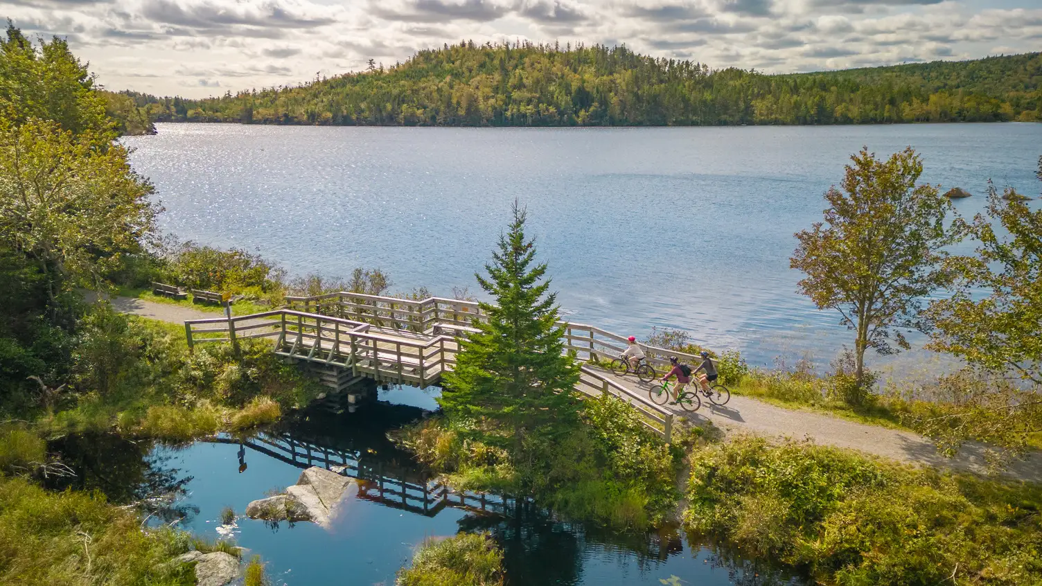
Aerial view of the Musquodoboit Trailway and wilderness trails on Nova Scotia’s Eastern Shore. Photo: Tourism Nova Scotia / Acorn Art & Photography
The Musquodoboit Trailway starts gently enough to fool you. You step onto a flat old railbed, the river slides past, and everything feels like a pleasant stroll with good scenery.
Then you notice the side trails heading up into the granite.
That’s the real decision here. The Musquodoboit Trailway is two trail experiences wearing one name: an easy rail trail that works for short walks, bikes, strollers, and river views, and a set of rough ridge loops that turn into proper hikes fast. Same parking lot, very different commitment.
This guide helps you pick the section that fits the day you actually have. If you want the wider picture of the village itself, our guide to things to do in Musquodoboit Harbour covers the stop as a whole. This one stays on the trail.
Quick Answer: Which Musquodoboit Trailway Route Should You Choose?
Walk the rail trail unless you’ve planned for more.
The rail trail is the easy default for families, bikes, strollers, and anyone who wants river views without a climb. Bayer Lake and Gibraltar Rock are short adventures with real effort baked in. Admiral Lake and the two Granite Ridge trails are full hikes, and the Granite Ridge routes can eat most of a day.
Distances below are the total you’ll walk from the car, not just the named loop. They’re rounded from the association’s trail descriptions, which are also the best place to check the route in detail before you go.
| If You Want… | Better Pick | Rough Total From the Car | Why |
|---|---|---|---|
| Easy walk | Rail trail from Park Road, out and back | Your call | Gentle grade, turn around anytime |
| River view, minimal effort | Museum-end stretch with the trestle | About 1 km return from Park Road | Short, flat, and the best river view on the rail trail |
| Short ridge loop | Bayer Lake Loop | About 5 km | Smaller taste of granite terrain |
| Short but steep view | Gibraltar Rock Loop | About 2.5 km | River lookoff from a steep granite climb |
| Longer hike | Admiral Lake Loop | About 9–10 km | Real hike without a full-day commitment |
| Full-day ridge hike | South or North Granite Ridge | About 16–19 km | Long, rough, committing |
| Family / stroller / bike | Rail trail only | Your call | Don’t assume side loops fit |
| Late start | Short rail trail section | Under 2 km | Avoid getting caught on a ridge late |
First: Rail Trail or Ridge Loop?
This is the choice that shapes everything else.
The rail trail follows a former railbed, so it’s wide, even, and close to level. The Musquodoboit Trailways Association lists its elevation range as only a few dozen metres across the whole run. You can turn around whenever you like, which makes it easy to match to your energy.
The ridge loops are another animal. Think granite slabs, roots, boulders, short steep climbs, and lookoffs you earn. They sit in or beside protected wilderness, and the going is slower than the distance suggests.
Here’s the trap: a 1 km loop on granite can take longer than 3 km on the railbed. Judge the ridges by elevation gain and footing, not the number on the sign. If you’re unsure, start on the rail trail. The ridges will still be there next time.
Where Does the Musquodoboit Trailway Start?
The trail officially begins at the caboose information centre at the Musquodoboit Railway Museum. From there it crosses the river on a trestle, crosses Highway 357, passes the arena and ball fields, and reaches the main trailhead parking lot at 90 Park Road.
That order matters. The trestle is on the short museum-end stretch, before the Park Road lot. If you park at Park Road and head out toward Gibraltar, you’re walking away from it.
Park Road is the starting point for the rail trail, Bayer Lake, Admiral Lake, and South Granite Ridge. Gibraltar Rock and North Granite Ridge start from a separate Gibraltar parking lot on Highway 357, farther inland. Double-check which trailhead you need before you drive, because showing up at the wrong end is a very specific kind of annoying.
From Halifax, the drive to Musquodoboit Harbour is usually somewhere around 45 to 60 minutes, depending on where you start and traffic. Use a live map on the day, and look for the trailhead signs by the ball fields when you arrive. If you’re building a bigger day along the coast, our Halifax to Eastern Shore day trip guide handles the driving route.
The Easy Option: Rail Trail from Park Road
This is the safest first pick and the part most visitors should start with.
The association puts the rail trail at about 14.5 km from the Park Road lot (roughly 15 km from the railway museum). It’s part of the Trans Canada Trail, and the association describes it as suitable for all ages, dogs on leash, strollers, bikes, and other active transportation.
You won’t walk all of it, and you don’t need to. Pick a turnaround point before you set off.
What’s the easiest first walk?
Two good options, and you can do both:
- For the river view: from Park Road, walk the short stretch back toward the museum to the 130-foot trestle over the Musquodoboit River. Going by the association’s 14.5 km and 15 km figures, it’s roughly half a kilometre each way.
- For a longer easy walk: head out from Park Road toward Gibraltar. The first picnic shelter, near Bayer Lake, sits around the 2.5 km mark, which makes a natural turnaround at roughly 5 km round trip.
Past that, the railbed keeps running through forest and wetland beside the river, with granite ridges rising alongside. Go as far as your legs and daylight allow, then remember you have to walk all of it back.
What facilities are along the rail trail?
Fewer than you might assume. According to the association, the toilet at the Park Road lot belongs to the ball park and is generally locked. Pit toilets and picnic shelters are listed at a few points farther along the trail, and the toilets aren’t maintained in winter. Treat them as helpful if they’re open, not guaranteed.
There are also no trash bins on the trails or in the lots, so plan to carry out everything you bring in.
Best for:
- A first visit
- A low-energy or short-on-time day
- Walking with kids
- Biking or pushing a stroller
- A leg-stretch on an Eastern Shore drive
The Short Adventure: Bayer Lake Loop
Bayer Lake is the small step up. It gives you a taste of the granite ridge without asking for your whole afternoon.
From Park Road, walk 1.7 km along the rail trail to the Admiral Lake trailhead, then follow that trail about 170 m to the Bayer Lake Loop. The loop itself is about 1.07 km. It drops back to the rail trail at the 2.2 km mark, leaving you a 2.2 km walk back to the car.
All in, that’s roughly 5 km from Park Road and back. Plan on about 1.5 to 2 hours for the whole outing, a bit more if you linger at the lookoffs or walk with kids.
The loop follows the edge of the ridge past lookoffs over Bayer Lake and the surrounding land. It’s short, but it’s rocky, uneven hiking. Wear proper shoes and leave the stroller on the railbed.
Gibraltar Rock Loop: Short, Steep, and Not the Same as Easy
Gibraltar Rock is short, but short does not always mean lazy.
Start from the Gibraltar parking lot on Highway 357. The association says to head about 100 m south to the loop entrance, then the trail climbs steeply to the rock, where a lookoff gives you a bird’s-eye view of the river and road below. From there it descends more gradually and rejoins the rail trail at the 1.1 km mark, so you’ll walk about 1.1 km back to the car.
That makes the whole outing roughly 2.5 km.
How hard is Gibraltar Rock?
Harder than its length suggests. The association lists 144 m of total elevation gain on the 1.3 km loop, and most of it comes early in the steep climb. Allow around 1 to 1.5 hours for the full 2.5 km outing, which is a lot of time for a short distance. The climb and the footing are why.
It’s a good pick if you want a view and have an hour or two to spare. It’s a poor pick for strollers, very casual walkers, or anyone who dislikes steep granite. Wet rock and fallen leaves make it slick, so skip it in rough weather.
Admiral Lake Loop and the Longer Ridge Hikes
This is where your casual walk starts asking follow-up questions.
What is the Admiral Lake Loop like?
Admiral Lake is the most manageable of the longer hikes, but it’s still a real hike. You walk 1.7 km along the rail trail from Park Road, then the loop runs about 5.15 km through old burn areas, mossy woods, cliffs, and a talus cave before returning to the rail trail at the 2.7 km mark. There’s an optional 340 m spur to Skull Rock, too.
Counting the rail trail in and out, plan on roughly 9 to 10 km from the car. The association lists close to 300 m of total elevation gain, and with that much rocky climbing, plan on 4 to 5 hours for the full outing. The payoff is a series of lookoffs over the forest, Musquodoboit Harbour, and the wilderness lakes to the north.
How far are the Granite Ridge hikes, really?
Farther than the headline numbers. The ridge trail distances don’t include getting there and back, and the return leg is long.
| Route | Start | Ridge Trail | Getting There and Back | Rough Total From the Car | Rough Time to Allow |
|---|---|---|---|---|---|
| South Granite Ridge | Park Road | About 8.8 km | 2.6 km approach on the rail trail, then about 7.2 km back via the trailway (or about 5 km via the Old Portage Trail) | About 16–19 km | 6–8+ hours |
| North Granite Ridge | Gibraltar lot, Hwy 357 | About 9.25 km | 1.1 km approach on the rail trail, then about 7.2 km back to the Gibraltar lot | About 17.5 km | 6–8+ hours |
Totals are rounded from the association’s route descriptions and depend on the return route you take. Check the South Granite Ridge and North Granite Ridge pages before committing.
Both run through rocky, rooty ridge terrain with roughly 500 m or more of climbing and repeated ascents to lookoffs. Times vary a lot with fitness, footing, and how long you linger at the views.
If you’re doing one of these, start early, bring food and water, carry a map, and tell someone your plan. This is not the place to discover at 3 p.m. that “loop” and “easy loop” are different concepts.
Trail Rules and Practical Notes
Based on the association’s current information, here’s what to know. Always check posted signage on the day, since rules and conditions can change.
- Dogs: The rail trail is designated on-leash.
- Motorized vehicles: Not permitted, except maintenance and emergency vehicles.
- Camping and fires: Not permitted on the rail trail or the wilderness trails.
- Ridge trails: Treat these as foot trails. The bike and stroller suitability applies to the rail trail, not the wilderness loops.
- Waste: No bins on trails or in parking lots. Pack out everything, including dog waste.
- Hunting season: The association recommends wearing orange in wilderness areas during hunting season.
- Conditions: Storms can bring down trees and damage sections, and maintenance is done by volunteers. Check the Musquodoboit Trailways Association site before you go.
What to Bring
For the rail trail, keep it simple: comfortable shoes, water, a layer, and a charged phone.
For the ridge loops, pack more deliberately:
- Sturdy shoes or boots with good grip
- More water and snacks than you think you need
- Layers, since the ridge and the river valley can feel different
- A charged phone and a downloaded or paper map
- Trekking poles if you like them on steep, uneven rock
- Bug protection in warmer months, and a tick check afterward
- Enough daylight to finish comfortably, plus a buffer
When the Musquodoboit Trailway Is Not the Right Choice
Sometimes the honest answer is “not today.”
If you want a polished town stroll with cafés every few minutes, this isn’t it. If what you really want is sand and surf, nearby Martinique Beach may be the better target. If it’s pouring or icy, the ridge loops are off the table, and a gentler outing like one of our easy fall walks near Halifax may suit you better.
Starting late? Skip the long loops entirely. And if you need reliable washrooms, don’t count on the trailhead. For more places along this coast, the Eastern Shore Nova Scotia guide picks up from there.
What Not to Do
- Don’t assume every trail here is easy because the rail trail is.
- Don’t judge a ridge hike by the loop distance alone. Add the walk in and out.
- Don’t start a Granite Ridge hike in the afternoon.
- Don’t let the map talk you into more trail than the day has room for.
FAQ
Where is the Musquodoboit Trailway?
It’s in Musquodoboit Harbour on Nova Scotia’s Eastern Shore, east of Halifax. It begins at the Musquodoboit Railway Museum, passes the main trailhead at 90 Park Road, and heads inland along the Musquodoboit River toward Gibraltar.
How long is the Musquodoboit Trailway?
The rail trail is about 14.5 km from the Park Road lot, or about 15 km from the railway museum. The association describes the whole system as over 41 km when you include roughly 26 km of backcountry wilderness trails.
Where do you park for the Musquodoboit Trailway?
Most people start at the main lot at 90 Park Road, by the ball fields. For Gibraltar Rock and North Granite Ridge, the Gibraltar lot on Highway 357 is the starting point. Check signage when you arrive.
Is the Musquodoboit Trailway easy?
The rail trail is. It’s a flat, wide former railbed. The ridge loops are not, and they range from short-but-steep to full-day hikes on rocky terrain.
Is the Musquodoboit Trailway good for kids?
The rail trail works well for kids, especially the short stretch to the trestle or a walk out toward the Bayer Lake shelter. For the ridge loops, it depends on the kids’ experience and stamina, so start small.
Can you bike the Musquodoboit Trailway?
You can bike the rail trail, which the association lists as suitable for bicycles. The ridge trails are rough foot trails, so leave the bike on the railbed.
Are dogs allowed on the Musquodoboit Trailway?
Dogs are welcome on leash, according to the association. Bring bags and pack out waste, since there are no bins on the trails.
What is Gibraltar Rock Trail like, and how hard is it?
It’s a 1.3 km loop from the Gibraltar lot on Highway 357 that climbs steeply to a lookoff over the Musquodoboit River, then eases back down to the rail trail. Expect about 2.5 km in total and 144 m of climbing. Allow around 1 to 1.5 hours, and wear shoes with good grip.
Is the Musquodoboit Trailway worth visiting from Halifax?
For a trail day east of the city, it’s a strong pick. The drive is usually under an hour or close to it, and you can scale the outing from a short river walk to a full ridge hike. If you only have a few days in the city, see how it fits with our 3-day Halifax itinerary.
The Short Version
The Musquodoboit Trailway is an easy rail trail with some serious ridge hikes attached. Treat them as separate plans.
Start with the rail trail, and don’t miss the trestle on the museum end. Bayer Lake and Gibraltar Rock are short adventures with real climbing. Admiral Lake and the Granite Ridge trails are proper hikes, and the Granite Ridge routes run well past 15 km once you count the walk back.
Pick the section that fits the legs you actually brought with you, the weather you’ve got, and the daylight left. Do that, and it’s one of the better outdoor stops on the Eastern Shore.