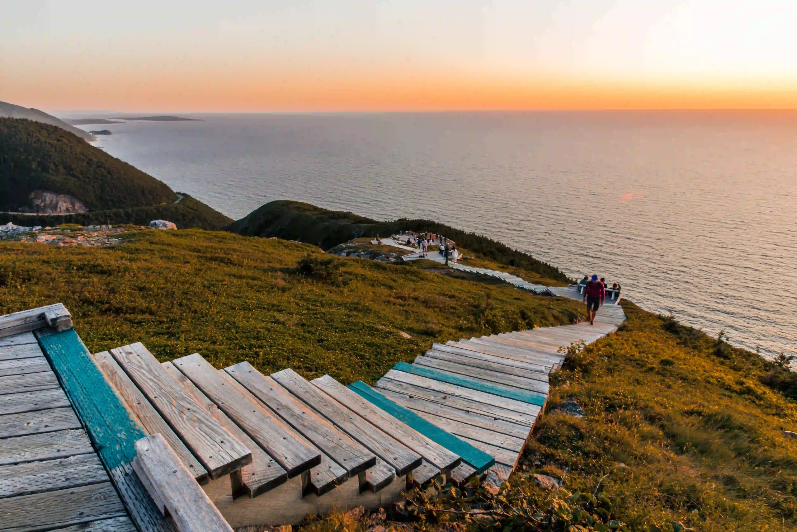
Skyline Trail Cape Breton: Parking, Distance, Difficulty, and Best Time to Go
Affiliate note: This article may contain affiliate links, which means I may earn a small commission if you book or buy through them – at no extra cost to you. I only recommend things that make sense for this kind of trip.
I hiked the Skyline Trail on a fall morning, the kind where the fog hasn’t decided yet whether it’s staying. Nobody else was on the boardwalk. Then a deer stepped out of the treeline about ten feet from the path, looked at me for a second, and wandered off like I wasn’t worth the trouble. That’s the Skyline Trail most people don’t get — the version without three hundred phones out at once.
This is one of Cape Breton’s most photographed hikes, and for good reason. But for 2026, Parks Canada has introduced peak-season parking reservations, so this is no longer a trail to treat as a casual pull-off if you’re visiting during the reservation window. Here’s how to plan around it — the real distance, how hard it actually is, when to go, what to bring, and whether it lives up to the hype.
Quick Answer: Skyline Trail Cape Breton
The Skyline Trail is Cape Breton’s most famous short hike for a reason: it gives you clifftop views over the Gulf of St. Lawrence without requiring a full-day mountain climb. The main out-and-back route is about 6.5 km return, while the full loop is about 8.2 km. Parks Canada rates the trail as easy, but the headland is exposed, windy, busy in peak season, and part of active wildlife habitat. In 2026, parking reservations are required during the peak season from June 26 to October 25, so check Parks Canada before you drive there.
| Question | Short Answer |
|---|---|
| Where is it? | French Mountain area, Cape Breton Highlands National Park, near Chéticamp |
| How long is it? | About 6.5 km return or 8.2 km loop |
| How hard is it? | Parks Canada rates it easy, but expect wind, exposure, and stairs |
| How long does it take? | Usually about 2–3 hours, depending on route and photo stops |
| Do you need to book? | In 2026 peak season, yes — check Parks Canada for current parking rules |
| Are dogs allowed? | Parks Canada says dogs are not permitted on this trail |
| Best time to go? | Early morning, late afternoon, or shoulder season if you want fewer crowds |
| Is it worth it? | Yes — if you plan ahead and don’t expect solitude at midday in peak season |
Skyline Trail Basics: Distance, Time, Difficulty, and Location
The Skyline Trail sits at the top of French Mountain, in Cape Breton Highlands National Park, about 15 minutes north of Chéticamp and right off the Cabot Trail. You walk through windswept boreal forest, and then the trees just stop. A boardwalk juts out over a headland cliff, and the Gulf of St. Lawrence opens up below you — the Cabot Trail curling down the mountainside looking like a toy road.
You’ve got two route options. The out-and-back to the headland and back is about 6.5 km. The full loop, which swings through more forest before reconnecting, is about 8.2 km. Parks Canada rates the trail as easy, and typical hiking time is 2–3 hours depending on route and how many stops you make for photos (you will stop for photos).
“Easy” doesn’t mean featureless. There’s a boardwalk and a set of steps down to the headland viewing platform, and the exposed clifftop can feel noticeably colder and windier than the parking lot — bring a layer even if the trailhead feels mild.
Do You Need a Parking Reservation for the Skyline Trail?
For the 2026 peak season, Parks Canada says parking reservations are required for Skyline Trail access from June 26 to October 25. If all parking reservations for a given window are booked, there is no access to the trail during that time — Parks Canada lists no general workaround. Drop-offs and roadside parking are prohibited, so don’t assume you can park along the highway if the lot is full. The one stated exception on the Parks Canada page is the Skyline Sunset Hike, a Parks Canada enhanced program with its own separate booking.
Book through the Parks Canada Reservation Service, and check the current Skyline Trail page before you go — fees, arrival windows, cancellation rules, and reservation details can and do change year to year. Parks Canada lists timed entry and specific arrival rules; read them before booking rather than relying on what you remember from a previous trip or a blog post (including this one).
At the time of writing, Parks Canada’s 2026 Canada Strong Pass affects park admission from June 19 to September 7, but admission is a separate fee from the Skyline parking reservation. Check current Parks Canada fee rules before planning your budget around it.
How to Choose: Out-and-Back vs Full Loop
| Route | Distance | Best For | Tradeoff |
|---|---|---|---|
| Out-and-back | About 6.5 km return | Families, first-timers, tighter schedules | Fastest way to the headland view |
| Full loop | About 8.2 km | Hikers who want more forest walking | Longer return, less dramatic than the boardwalk view |
If you’re deciding between the two: the loop adds forest walking that’s pleasant but not dramatic, while the out-and-back gets you to the headland faster and lets you retrace your steps at your own pace. Families and first-time hikers tend to prefer the out-and-back. If you’ve got the extra time and want the fuller experience, take the loop.
When Is the Best Time to Hike the Skyline Trail?
Every season here has a personality, though services and conditions shift enough that it’s worth checking current park status before you build a trip around a specific month — especially outside peak summer.
Spring (May–June) brings wildflowers and thinner crowds, but snow can still linger on the plateau. Pack layers regardless of what the forecast says.
Summer (July–August) tends to be the busiest and most reliable for weather, and also when you’ll be sharing the boardwalk with the most people, particularly between 11am and 4pm.
Fall (September–early October) is when I went, and it’s hard to argue with. Cooler air, fewer people, and the highlands turn into a wall of orange and red. If your timing lines up, Celtic Colours Festival runs mid-October across the island and pairs well with a Cape Breton hiking trip — fiddles by night, cliffs by day.
Winter is open, but services and access are limited — check current park conditions, road status, and daylight hours before planning a shoulder-season or winter hike.
Whatever season you pick, going early morning or in the last couple of hours before sunset tends to mean quieter conditions and softer light for photos — not a guarantee of wildlife, just better odds of a calmer trail.
What If the Skyline Trail Is Fully Booked?
It happens, especially on weekends in peak season. Cape Breton Highlands National Park has 26 trails in total, and a few are worth researching as alternatives.
Middle Head, near Ingonish, is a moderate loop out along a narrow peninsula with ocean on both sides — a similar payoff to Skyline in terms of coastal drama, though it’s on the opposite side of the park, so it makes more sense if you’re already based near Ingonish. Franey Trail is steeper and harder, with a summit view over the Clyburn Valley. Acadian Trail, closer to the Chéticamp side, is more forested and a quieter option if crowds were the whole reason you were hesitating about Skyline in the first place.
Check the current Parks Canada trail list and conditions before you go, since access and difficulty ratings can shift by season. For more options across the island, the Nova Scotia hiking guide covers trails beyond Cape Breton too.
Wildlife, Moose, and Boardwalk Rules
Moose are possible on this trail, not guaranteed — the Highlands has a real population of them, and they’re large enough that giving them a wide berth isn’t a suggestion, it’s common sense. Don’t approach or feed any wildlife you encounter. Bears are also present in this habitat, even if less commonly seen from the boardwalk.
Parks Canada prohibits dogs on this trail because they can disturb wildlife, especially moose and bears. Stay on the boardwalk and marked trail — the headland vegetation is fragile, and stepping off it for a better photo does real damage. If you’re hiking with kids, keep a close eye on them near the cliff edge and viewing platform.
I got a deer instead of a moose, which felt like a smaller but no less good version of the same deal — a reminder that you’re a guest out there, not the main event.
What to Bring for the Skyline Trail
The trail doesn’t demand technical gear, but the plateau has its own weather system, and being underprepared is the difference between a great hike and a miserable one.
- Water and a real snack. There’s no water source on the plateau, and wind alone will dehydrate you faster than you’d expect.
- Layers, including a wind or rain shell. Conditions change fast on French Mountain — clear skies at the trailhead don’t guarantee clear skies at the lookout.
- Grippy, sturdy footwear. The trail is mostly flat and well-maintained, but the boardwalk gets slick when wet, and the steps down to the headland aren’t where you want worn-out tread.
- Sun protection. There’s almost no shade once you clear the treeline.
- Insect repellent, especially between June and August, when black flies and mosquitoes are common in the boreal sections.
- A charged phone, plus a screenshot or offline copy of your parking reservation in case service is spotty at the gate.
- Binoculars (optional) for spotting moose at a distance or scanning the water for whales from the viewing platform.
- A hat and gloves if you’re hiking in the shoulder season — the headland wind makes a bigger difference than the trailhead temperature suggests.
Safety, Weather, and Trail Etiquette
This is rated an easy trail, not a risk-free one. A few things worth keeping in mind:
- Weather on the headland — wind, fog, rain — can shift faster than it does at the trailhead or in Chéticamp.
- The boardwalk and stairs can be slippery when wet; slow down rather than rushing the descent.
- Stay back from the cliff edges, even where there’s no barrier.
- Stay on the boardwalk and marked trail at all times, both for your safety and to protect the vegetation.
- Don’t approach wildlife, no matter how calm or far away it looks.
- Bring more water than you think you need — do not count on services once you are on the trail.
- Cell service can be unreliable on the headland; don’t count on it for navigation or emergencies.
- No roadside parking or drop-offs during the reservation window — check current Parks Canada rules before assuming otherwise.
- If the weather turns ugly, it’s fine to turn back and try another day. The view is the entire point of the hike, and a socked-in headland isn’t it.
Check current conditions on the Parks Canada Cape Breton Highlands page before you drive out, especially outside peak summer.
Is the Skyline Trail Worth It?
Yes — it earns the reputation, and that’s not something I say about every trail with a strong Instagram presence.
It’s an especially good pick if this is your first Cabot Trail visit and you want one hike that delivers the highland-meets-ocean view without technical difficulty. It’s a worse pick if you’re hoping to fight midday crowds in peak season without a reservation, or if you’re after a technically challenging hike — this isn’t that. Go for the view, go in the shoulder season if you can, and plan around the reservation system rather than against it.
Where to Stay Near the Skyline Trail
Chéticamp is the closest town to the trailhead, with a real range of guesthouses and inns, and enough restaurants that you’re not stuck eating gas station snacks after a full day outdoors. If you’re pairing this hike with Middle Head or Franey Trail, Ingonish on the east side of the park makes more sense as a base instead.
While you’re on this stretch of the Cabot Trail, it’s worth building in a stop at Pleasant Bay, about 30 minutes north of the trailhead, where whale watching in Pleasant Bay tours run for most of the season.
For the full breakdown of where to stay by town and price range, see the where to stay in Cape Breton guide. And if you’re still mapping out the rest of the island, start with the Cape Breton itinerary — this hike fits neatly into it as a single, focused day.
FAQ
Do you need a reservation for the Skyline Trail? For the 2026 peak season (June 26–October 25), yes — Parks Canada requires a parking reservation. Outside that window, check current Parks Canada rules, since they can change.
How long is the Skyline Trail? About 6.5 km return on the out-and-back route, or about 8.2 km for the full loop.
How hard is the Skyline Trail? Parks Canada rates it easy. It’s mostly flat with a boardwalk and some steps near the headland, but the exposed, windy conditions and busy peak-season crowds make it feel less casual than “easy” might suggest.
Is the Skyline Trail good for beginners? Generally yes, especially the out-and-back route. First-timers should still expect wind, some stairs, and no shade on the headland.
Are dogs allowed on the Skyline Trail? No. Parks Canada does not permit dogs on this trail because they can disturb wildlife, especially moose and bears.
Can you hike the Skyline Trail without a car? It’s difficult — the trailhead is on French Mountain along the Cabot Trail with no regular public transit. Most visitors drive or arrange a tour that includes transportation.
What happens if Skyline Trail parking is full? Parks Canada doesn’t offer a general workaround once reservations are fully booked. Consider an alternative trail like Acadian, Middle Head, or Franey, and check current park conditions before you go.
Is the full loop worth it? If you have the extra time, yes — it adds pleasant forest walking, though the headland view itself is the same as the out-and-back.
When is the best time of day to hike the Skyline Trail? Early morning or the last couple of hours before sunset tend to be quieter, with softer light for photos.
Can you see moose or whales from the Skyline Trail? It’s possible but not guaranteed. Moose live in this habitat, and whales are sometimes visible from the headland viewing platform on clear days. Keep a respectful distance from any wildlife you see.
The Short Version
The Skyline Trail is still one of the easiest yeses in Cape Breton — short enough for most visitors, dramatic enough to justify the reputation, and complicated enough now that you shouldn’t treat it as a casual pull-off in peak season. Book if your dates require it. Go early if you can. Stay on the boardwalk, give wildlife space, and bring a layer even if Chéticamp feels warm. The view is famous for a reason. The planning is now part of earning it.
Still mapping out the rest of Cape Breton? Start with the Cape Breton itinerary. If this trip is turning into a wider Nova Scotia road trip, the Nova Scotia itinerary covers the bigger loop.
Have you hiked the Skyline Trail, before or after the new reservation system? I’d love to hear how it compared — drop it in the comments.